
Over winter break, we were traveling south for a celebration in Mexico with Laura’s Mom’s side of the family. In celebration of their 80th birthdays, Laura’s aunt and uncle, Anne and Carl, were generously flying everyone on that side of the family to the Cancun area in Mexico, and they were paying for us to stay at a resort in Puerto Morelos as well. To take full advantage of this opportunity, Laura and I decided to go to Mexico a few days before the group would arrive and stay on Isla Mujeres. We landed in Cancun on 12/22.
If you haven’t flown into Cancun’s airport before, it is the kind of airport a city might design if they DIDN’T want tourism. Inside of the airport, people selling timeshares and tours are allowed to set up at tables as if they are customer service stations, masquerade as government employees, and prey on people disoriented by hours of having their seat kicked by a toddler. The airport is so bad that the transportation company we were using to get to the Isla Mujeres ferry included this in their email confirming our car:
The area right outside of the airport is almost as crazy, with dozens of drivers for dozens of transportation companies picking up dozens of groups.
Even before we arrived to experience close calls with aggressive time-share salespeople in airport personnel clothing, Anne was providing plenty of warning about the dangers of travel to Mexico. She warned that people should:
- Not wear earrings because roving hooligans will literally rip them out of your ears.
- Bring a burner phone to safeguard your phone against theft.
- Not check a bag at the airport because bag retrieval could take up to two hours in Cancun.
We eventually escaped from the airport without being lured into a time-share purchase or witnessing savage earring assaults, and we made it to the Isla Mujeres ferry in time for the 6 pm departure. Isla Mujeres sits right across the narrow Bahía de Mujeres from Cancun, about a 20 minute ferry ride.
Across the bay, we disembarked and found a cab at the taxi stand, which is conveniently located next door to the ferry terminal. Then we defied the laws of physics to jam all of our luggage into a compact car and made it to Izla, our resort, for a leisurely evening.
Golf Cart Adventures
Isla Mujeres is around 4 miles long, with our hotel located almost in the middle. We knew that we would be spending most of our time on the northern and southern ends of the island, and we wanted the freedom to get around without having to rely on taxis and busses.
Therefore, we decided to maximize our sightseeing opportunities by joining the masses and renting a golf cart. There are more golf carts than cars on the island, so we were in good company.
One problem with renting a golf cart was that Laura couldn’t remember the name of the the thing that we had rented. She kept referring to our ride as a “go cart.” Thus, “golf cart” joined the pantheon of “Names Laura Will Never Remember,” taking its place with “EarPods” for AirPods and Laura’s name for McKenna’s Greenlight Debit Card: her “Green Card.”
There are crazy scooter drivers and random speed bumps all over Isla Mujeres, so letting Laura be the primary driver of the cart was the right call, saving us from approximately 12,537 yelled warnings to apply the brakes and from at least a thousand predictions that we were about to die. Those numbers would probably have been even higher because we used our cart to tour the island in all weather.
Along the edges of the center of the island run two major roads. Normally, we took the eastern road, the Payo Obispo, when we were driving north because this was a more scenic drive along the Caribbean Sea.
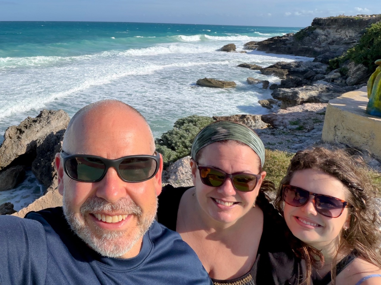
One of the stops along the way was the viewpoint from the cliffs, which had monuments to the sealife around the island and fantastic views of the Caribbean.
Throughout our time at Isla Mujeres, it was super windy, so windy that Laura’s magnetic sunglasses attachment was blown off of her prescription glasses. The fact that someone would wear magnetic sunglasses and, even worse, allow that fact to be known in public was totally mortifying to teenaged McKenna, in spite of the fact that we were on an island with exactly zero people that she would see again, ever.
The weather was beautiful almost the entire time we were in Mexico, but the wind was especially intense on the Caribbean side of the island. A plus was that the wind did make for some very cool waves hitting the rocks.
Punta Sur
The southern point of the island, Punta Sur, is by far the most impressive part of Isla Mujeres. The area is located at the highest point of the island, overlooking the Caribbean cliffs as well as the bay between the island and mainland Mexico.
The combination of the cliffs, rock formations, and the bright blue water is spectacular. As was always the case on this trip, the wind gusts were strong, creating some pretty dramatic waves.
There is a park with trails at Punta Sur, with a small admission fee to enter the park and walk around, about $6 USD for adults. The park includes a Mayan holy area, but much of the original ruins located there were destroyed by Hurricane Gilbert in 1988.
The temple that had been located there was dedicated to the goddess Ixchel, the deity of childbirth, fertility, and the moon. Isla Mujeres was one of the first parts of Mexico that Spanish conquistador Hernán Cortés and his crew visited in 1517, on his way to destroying the Aztec Empire. On the island, they found female-shaped idols dedicated to Ixchel and decided to name the whole island after them.
Mayan settlements on Isla Mujeres date back about 1500 years, and the Mayans first used the island for fishing and trade. I know this not because I bothered to learn the language of the place we were visiting and to use that knowledge to read the placards beside the Mayan statues, but because McKenna and Google Translate teamed up to overcome our ignorance of local customs.
The cliffs at Punta Sur were really high, and there was only a small barrier between the edge and a long fall onto the rocks. Fortunately, there were signs unmistakably warning park visitors of the danger.
At the southern tip of the island is a reconstruction of the area that had been dedicated to Ixchel. There is a stairway that leads all the way down to the shoreline, with some overlooks at a safer, higher level.
Down one level from the top was the Cliff of the Dawn, marking the easternmost point of Mexico. The placard recommended that we come back at dawn to be the first to see the sunrise.
The rock in the area is a limestone that had been made from remnants of sealife and parts of the Mesoamerican Reef, and the weather and waves have created jagged rock surfaces.
The stairwell continued to go down after this platform, to an area that was washed enough by water that it was very slick.
While there were people who chose to walk on this lowest level under the Cliff of the Dawn, some of them looked like they were getting pretty wet, and you see below just how much the ocean floods the lowest-level walkway.
We opted to go back up to the top rather than walk on the slippery rocks, and we were rewarded for our good sense when we later found a much safer seaside path. This pass bypassed the most sea-washed parts of the trail, and it was safe enough that it met with the approval of our temporarily pro-parent teenager.
Our trip to Punta Sur coincided with the one time we got some rain during our almost 3 days on the island, with small storms clipping the southern part of the island while there were still blue skies to the north.
After completing our circuit of the safe Punta Sur seaside trails, we headed north toward those blue skies.
Next up: Playa Norte!
2 responses to “Seaside Cliffs and Carts that Go on Isla Mujeres”
[…] winter break, our Christmas season trip to Isla Mujeres continued, as Laura, McKenna, and I headed north from Punta Sur to the opposite end of the island […]
[…] McKenna and I had arrived in Mexico a few days earlier, and we made our way back to the mainland from Isla Mujeres. Meanwhile, the rest of the family was […]